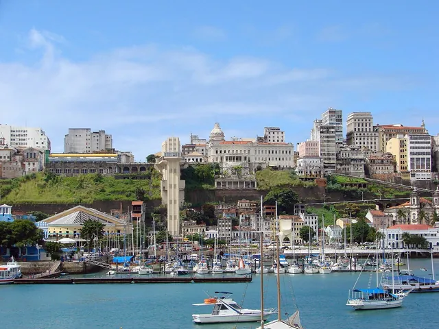
The Upper Town
From Praça Tomé de Souza you can see how the escarpment shapes the map. The Upper Town held administrative and residential functions, while the port and commerce developed below. Salvador was Portuguese America’s first capital from 1549 to 1763. UNESCO inscribed the Historic Centre in 1985.
Walk through Terreiro de Jesus to Largo do Pelourinho. The street pattern and townhouses are part of the colonial record, including the enslavement of Africans. The MAFRO collection, described in the Afro-Brazilian guide, puts those façades in wider context.
The Lower Town
Mercado Modelo and Cidade da Música da Bahia stand on Praça Visconde de Cairu. The Lacerda Elevator links the square to the top of the escarpment. Walking each level in its own block gives you time to see how they fit together.
If the elevator is out of service, continue on the level you are already on and plan the descent again. Check official channels for market and museum opening and last admission.
Barra between two waters
The lighthouse stands at Forte de Santo Antônio da Barra at the entrance to the bay. The public walk by Porto da Barra gives a different view of the water. Give the coast its own block and allow a break.
Decide on swimming on the day. Check INEMA’s water-quality bulletin, signs and conditions on site. Keep the promenade walk as an alternative.
Carmo and Rio Vermelho
Santo Antônio Além do Carmo extends the walk through the historic area, with slopes and bay views. In Rio Vermelho, the house where Jorge Amado and Zélia Gattai lived holds material on the writers’ work.
Pick one if you have a single period free. Carmo fits with the Upper Town. Rio Vermelho deserves time for a meal and the walk to Rua Alagoinhas.
Where to stay and how to extend the trip
For days on foot in the centre, assess the area around your exact address. Compare Barra and Rio Vermelho for waterfront time. Plan the airport trip and the final leg to your door.
INMET’s 1991–2020 normals for Salvador give monthly rainfall of about 285 mm in April and 302 mm in May. Allow for an indoor alternative and check the forecast and venue notices for your dates. Give an outing to the bay or the north coast a day of its own. Check boarding, return, sea conditions and language before fitting it in. The experiences guide identifies published offers and unresolved details.
Contextual glossary
Pelourinho
The district’s name recalls a pillory, a post used for public punishment and associated with slavery. The capitalised word in this guide names the place. The Historic Centre covers a wider area.
Sources consulted
- UNESCO · Historic Centre of Salvador de Bahia
- IPHAN · Patrimônio Material na Bahia
- Visit Salvador da Bahia · Elevador Lacerda
- Visit Salvador da Bahia · Mercado Modelo
- Visit Salvador da Bahia · Cidade da Música da Bahia
- Visit Salvador da Bahia · Porto da Barra · área de banho
- Visit Salvador da Bahia · Farol da Barra · Museu Náutico
- INEMA · Qualidade das praias · boletim de balneabilidade
- Visit Salvador da Bahia · Casa do Rio Vermelho
- Visit Salvador da Bahia · Roteiros rápidos: Santo Antônio Além do Carmo
- Salvador Bahia Airport · Como chegar ao aeroporto
- Motiva / Metrô Bahia · Mapas do Metrô Bahia
- Civitatis · Bay of All Saints islands
- Civitatis · Praia do Forte and Guarajuba
- INMET · Salvador · precipitação de abril e normal 1991 a 2020
- INMET · Salvador · precipitação de maio e normal 1991 a 2020
Consulted on · .
AI assisted the research and writing for this guide.